How to Read a County River Valley on a Map
Learn how to read a county river valley on a map by tracing its slopes, tributaries, crossings and settlements, and see where the terrain directs movement.
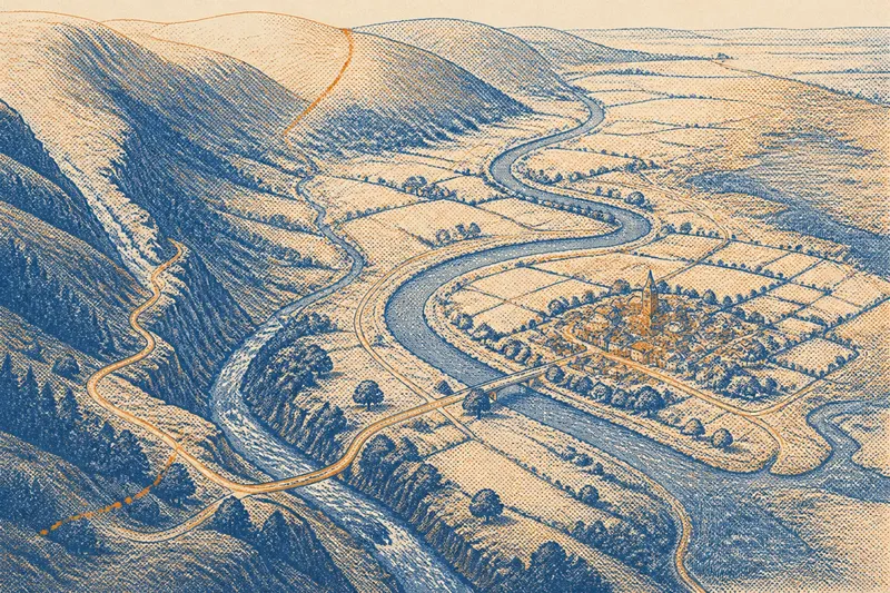
A county river valley is easiest to understand when you trace what changes along it, not when you treat the river as a line that explains everything. On a relief map, compare the valley floor with its slopes, tributaries, roads and settlements; their positions show where the terrain offers a route and where it constrains one.
Imagine a wholly invented county called Merewick. Its river runs from western uplands towards an eastern plain, passing through a wooded gorge, a broad bend and low marshy ground. A road follows the valley for part of the way, then leaves it. This made-up place lets us examine map relationships without suggesting that every county follows the same pattern.
Read the valley floor
A river valley is a lower corridor between higher ground, not merely the blue line on a map. Contour lines, spot heights and shaded relief reveal where the corridor narrows, widens or turns. On a road map, transport lines and place names can obscure those changes, so switch to a topographic layer when possible.
In Merewick, the western stream runs between close slopes, leaving little level ground beside it. Farther east, the valley opens and can accommodate broader fields and more routes. The contrast helps explain why a road might cling to one section but take a different line through another.
Follow the valley as a sequence. Note where its floor broadens, where a ridge approaches the channel, and where the river changes direction. These transitions are more informative than a single observation about the river’s course.
Compare slopes and routes
Slopes determine how easily a route can move between the valley and higher ground. On a topographic map, tightly spaced contours indicate a sharper rise; wider spacing indicates gentler terrain. A bench is a relatively level strip on a slope, while a saddle is a lower passage between higher points. Either may offer a route when the valley floor is cramped.
In Merewick’s gorge, a road might leave the river and follow a hillside bench before reaching a saddle. On the gentler eastern slopes, it might instead stay near the valley floor. These are possible relationships, not proof that terrain alone determined the route; settlement links, land ownership and later changes may also matter.
When a road turns uphill, compare the turn with the contours and nearby passes.
Trace tributaries carefully
Tributaries drain side valleys into the main river, but they do not all form useful travel corridors. A gently sloping side valley may connect the main route to farms on higher ground. A steep, wooded hollow may carry water while offering no easy passage.
In the invented Merewick, a northern tributary meets the river beside a lane leading to scattered farms. A southern stream runs through a steep-sided hollow with no mapped road. Both feed the same river, yet their shapes suggest different levels of access. Compare watercourses with contour lines, land cover and route markings before treating drainage as a guide to travel.
Inspect crossings and settlements
A bridge connects two banks, but its position makes more sense when you inspect both approaches. Roads may converge where slopes are manageable or where a side route meets the valley. A bridge symbol alone does not reveal why the crossing was chosen or whether earlier routes followed another path.
Settlements also occupy varied ground. A cluster may stand on a terrace above the lowest part of the valley, near a crossing or at the mouth of a side valley. Compare its height and access with the river, nearby slopes and roads. A map can show those relationships, but it cannot establish a settlement’s full history or explain every decision behind its location.
Say you are reading a wholly invented map of Merewick and begin with three observations: the main road enters a steep gorge, a northern tributary joins near a broad bend, and the largest settlement sits on a low rise beside the bend. First, you check the contours and see the road leave the river where the gorge tightens; the map supports the idea that the slope constrains the route. Next, you trace the northern tributary and find a lane following its gentler side valley; it appears to connect the bend with higher farms. Finally, you compare the settlement with the river and see that it is close to the crossing but above the lowest ground. The resulting reading is that the bend brings routes and settlement together on more accessible ground, while the map alone cannot tell you why the settlement first formed there.
Questions about river valleys?
Why does a road leave the river?
It may avoid a gorge, reach a saddle or connect places on higher ground. Compare the road’s turn with contours and nearby passes to see which terrain features may be relevant.
Why is a settlement above the river?
A terrace or gentle rise may offer access to the valley without occupying its lowest ground. The map shows position and terrain, but not the complete history behind the choice.
Does every tributary make a route?
No. A steep or wooded side valley can drain towards the main river while remaining difficult to follow. Check its gradient, land cover and mapped roads before treating it as a passage.
Can a river mark a county boundary?
Sometimes a river forms part of a boundary, but administrative lines may also cross valleys or follow ridges. Compare a county boundary map with relief rather than assuming the two coincide.
Check the map evidence
Use a paper topographic map or a digital map with relief shading. At a broad county scale, small banks and lanes may disappear, so check a more detailed view before drawing conclusions. For each observation below, record what the map shows and decide what it supports.
- Check whether the valley floor narrows or widens; if it narrows beside a road, consider whether the route may be constrained, then check for a bench or pass before deciding.
- Check contour spacing along the slopes; if contours are close, treat the ground as steep and look for a gentler alternative, but if they are widely spaced, consider whether a direct route is plausible.
- Check where tributaries meet the main river; if a road follows a side valley, consider it a possible connection, but if no route is shown, treat the stream as drainage rather than assumed access.
- Check both approaches to each mapped crossing; if roads reach both banks over gentler ground, note a likely route link, but if an approach is steep or absent, avoid assuming the crossing serves an easy through-route.
- Check a settlement’s position against the channel and valley floor; if it sits on a terrace with nearby roads, note the combination of elevation and access, but if the map is too coarse, defer judgement until a detailed layer is available.
- Check whether the county boundary follows the river; if it does, record that local alignment, but if it crosses the valley or follows a ridge, use the mapped administrative line rather than the watercourse.
For a real county, this method of reading a county river valley on a map separates visible relationships from explanations that the map cannot provide. The valley may guide movement, while slopes, tributaries, crossings and settlement positions qualify its influence. Read each feature in relation to the ground around it, and keep historical or administrative questions distinct from what the terrain itself shows.